My friend, Tina, walked in one day and dropped a coffee table book on my desk: Kilimanjaro.
“So, why did you buy a book about Kilimanjaro?,” I asked. She said, “I am going to climb it and you guys should too.” I laughed and said, “Riiiiiight.”
48 hours and a couple of bottles of wine later, the three of us had decided that we were going to Africa.
Kilimanjaro
Kilimanjaro is the highest peak in Africa at 19,340 ft or 5,895 meters. It has three volcanic cones – Kibo, Mawenzi, and Shira, with its highest summit being Uhuru Peak on Kibo’s crater rim.
Hans Meyer, a German geology professor, along with Ludwig Purtscheller, an Austrian mountaineer, and their climbing team reached the summit of Kibo in October of 1889. Previous attempts by multiple parties were not successful due to the deep snow and ice on Kibo at the time.
Kilimanjaro today
There are six official trekking routes on Kilimanjaro today – Marangu (also known as the Coca-Cola route), Rongai, Lemosho, Shira, Umbwe, and Machame (also known as the whiskey route).
You’ve probably guessed which route we chose. Actually, Machame is the most scenic route and is longer than Marangu, so it has a better success rate. But, yes, we climbed the whiskey route.
The Kilimanjaro National Park shows that only 41% of trekkers actually reach the Uhuru summit at 19,340 ft, with the majority turning around at Gilman’s Point, 300 metres (980 feet) short of the summit, or at Stella Point 200 meters(660 feet) short of Uhuru, or before ever reaching the crater.
What were we thinking?
At the time, we were going to the Caribbean five or six times per year and had taken to climbing rain forests in the likes of St Kitts, Guadeloupe, and Martinique. Our typical climb consisted of getting up (too late as always), driving to the mountain, hauling ourselves up the mountain, coming home very muddy, taking a shower, and heading out to the beach with a glass of champagne to relax before dinner.
I had never slept in a tent at this point. And, I hated the cold.
Kilimanjaro: Training & preparation
So we had decided to climb Kilimanjaro. Now what?
How do you train to climb a 19,340 ft peak when living at sea level in Dallas? It was March and we had arrived on August as our climbing date, so we had 5 months to prepare. We put together a plan.
Our training plan
1. Train harder & more often. We got frame packs (big ones), added three 2-liter bottles of soda (weighs about 60 lbs), and climbed parking garages at the nearby shopping center every morning. Seriously. Our theory was to make it as hard as possible at sea level to simulate it being harder when we got to altitude.
We’d get up at 5 AM every day before work, hike to the mall with our packs and climb the stairs over and over. Sometimes, for variation, we’d walk up the ramps. At 7 AM, we’d be at the front door of Panera when they’d open to have breakfast and then head home for a shower before going to work.
After work, we’d hit the gym with the packs on the stair master. Rinse, and repeat the next day and every day thereafter for 5 months.
2. Fly to Colorado or California and climb 14ers. We started with Guadelupe Peak in Texas, then moved on to 14ers – Pikes Peak, Mt Evans & Mt Shasta – then decided we needed a break and went to Guadeloupe.
That was pretty much it. We actually got in great shape by the time we went in August with our homemade training plan.
Preparations

© Chasing Light Media
So, in addition to shots for all kinds of weird things and getting a Visa for Tanzania, we became the most frequent REI customers ever. I thought they were going to give us green vests. We bought everything anyone could imagine ever needing in the wilds of Africa. From sub-zero sleeping bags to water filters to down booties for camp, we had it.
The Kilimanjaro climb begins in a rain forest, works through the tundra, then ends up at very far below 0° on the way to the summit – so you need a lot of stuff. But, let’s face it – I also love gear.
Dealing with the cold
Growing up in Kansas, my Mom would send me out to play in the snow with bread bags over my mittens for waterproofing. Needless to say, it didn’t work and I learned to hate the cold and thought that snow was dreadful.
After hiking along the Continental Divide on one very windy, very cold day, we went back to a local hiking shop in Dallas and told them we wanted the warmest gloves made. They produced North Face Himalayan Mitts. They are amazing – I still wear them on cold ski days. The takeaway – with the right gear, most times you don’t get cold.
Anyway, we bought and bought and bought, then put it all in zip lock bags, stuffed it in 4 or 5 massive duffle bags and we were ready, almost.

Here’s how you give yourself a shot of dex
Very high altitude is considered between 11,500 and 18,000 ft and extremely high altitude is over 18,000 ft.
When you go to high altitude, potentially two serious issues can occur beyond normal acute mountain sickness (AMS) – high altitude pulmonary edema (HAPE) and high altitude cerebral edema (HACE). HAPE is basically when fluid forms in the lungs and HACE is swelling of the brain.
First, there is a preventive drug you can take during the climb for normal AMS called Diamox. It makes beer taste awful. But, if you get HACE or HAPE, you have to get to lower elevations quickly or you may die. There is also a drug, called Dexamethasone, or dex, that can help save you along the way. Our doctor recommended we take some with us and said her nurse would come in and show us how to give ourselves a shot, just in case we needed it.
The nurse comes in wearing scrubs, turns around, pulls down her pants on one side (she had on a thong), and proceeds to give us our dex instructions on her bare butt. Most bizarre doctor visit we’ve ever had.
Kilimanjaro: Travel & pre-climb time
Just before we left for Tanzania, we were invited to a friend of Tina’s house who had just returned from climbing Kili. While we were looking at his photos, he said, “Africa will change your life.” We smiled and mumbled something like I’m sure it will.
But, he was right. It did.
Heading to Africa
We flew from Dallas to Amsterdam (9 hours) on a jam-packed KLM flight in coach and stayed in Amsterdam that afternoon and night.
Schiphol airport is my favorite airport anywhere – it’s its own little city. We took the train into the city in the afternoon and the first thing we saw when we got off were two completely naked girls, spray-painted bright blue from head to toe, just walking down the street. Amsterdam. Bought a watch, had some beers, then went back to the hotel.
The next morning we flew from Amsterdam to Kilimanjaro airport (8 hours), arriving late in the evening. A bus picked us up and took us to Moshi, a small village at the foot of Kilimanjaro, where we would stay for the next few days before the climb.
Moshi time
Our hotel in Moshi was a compound, with a high wall surrounding the hotel. In the center was a great courtyard with a bar. Kilimanjaro beers were 80 cents and they served an amazing grilled cheese with tomatoes. We spent a lot of time in the courtyard.
When we wanted to go out, we were assigned an escort named Peter, who always carried a machete.

The first day Peter took us on a hike in an area nearby. We met some local children along the way and quite a few monkeys.
Since we were going to be on the mountain for a week, Greg came up with the idea that we should have our hair done in cornrows. One of the managers at the hotel was named Patience said she took us to her beauty shop and arranged it. When we went to town, we created quite a stir, with half the village coming by the salon to watch us get our new ‘dos.

Our time in Moshi before the climb was great. Everyone was helpful, fun, and very kind. But, the time had come to start climbing.
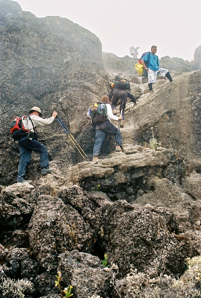
Kilimanjaro: Machame Route Day 1
Machame Gate to Machame Camp

Machame Gate (1634 m/5,363 ft) to Machame Hut (2834 m/9,300 ft)
Hiking time: Approximately 7 hours
Distance: Approximately 10 km / 6.21 miles
Habitat: Forest

We left the hotel and traveled to Moshi, where we met with our outfitter, Zara. Porters and guides were preparing and organizing our gear and the tremendous amount of supplies they would carry up the mountain with us.
Our group of five would be assisted on the climb by a guide, two assistant guides, 10 porters, and a cook. Next, we were driven to the Machame gate, where we signed in, took some pictures, and then headed into the rainforest.


Porters would pass us, practically running up the mountain while carrying huge loads, some of them wearing flip flops.


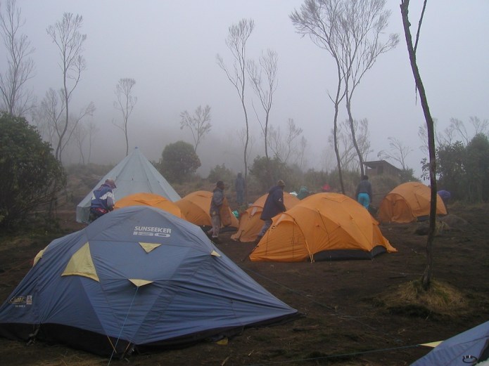
We climbed through the rainforest all day, through fog and mud, until we reached our camp.


When we arrived at our first campsite our tents were already set up and the porters immediately brought us warm water so we could wash before dinner and they then took our bottles to refill with water.

On this note – we all got sick from the water while on the mountain. Even if someone says they boiled the water – we highly recommend treating it as well.

We wandered around a bit before dinner, signed the register, and organized our gear in the late afternoon. A blanket was spread on the ground and we enjoyed our first dinner on Kilimanjaro. After dinner, it quickly became cold and we retired to our tents for the night.

Kilimanjaro: Machame Route Day 2
Machame Hut to Shira Hut

Machame Hut (2,834 m/9,300 ft) to Shira Hut (3,749 m/12,300 ft)
Hiking time: Approximately 7 hours
Distance: Approximately 6 km / 3.75 miles
Habitat: Moorland (mostly rocky, sandy, windy)
After breakfast, we got our daypacks ready and headed out.

Pole, pole


Our guide, Freddy, slowly led us on our trek up and across the valley, telling us, “Pole, pole,” (Swahili for slowly, slowly).


Occasionally, we’d catch up with other hikers who were climbing by themselves. They’d join us for a few hours, or sometimes a day, and then they’d either turn back down or decide to go slower.


It was very windy on day two and the temperature ranged from chilly to hot.


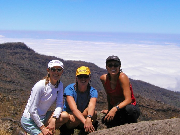

We arrived at the Shira camp late afternoon. Shira camp is located on the Shira plateau in the high moorlands.


After organizing and cleaning up, we hiked around near camp. Shira camp has some great opportunities for photographs of Kibo and Mt Meru in the late day sun. Then, dinner and tent time, as it grew cold.


Kilimanjaro: Machame Route Day 3
Shira Hut to Lava Tower to Barranco Hut

Shira Hut (3,749 m/12,300 ft) to Barranco Hut (3,901 m/12,800 ft)
Hiking time: Approximately 7 hours
Distance: Approximately 15km / 9 miles
Habitat: Moorlands to alpine desert
A key part of acclimatization is summed up in the popular saying, “Climb high, sleep low.”

Day 3 is a good example of this. We started out at 3,749 meters, climbed to 4,642 meters, and then headed down to 3,901.
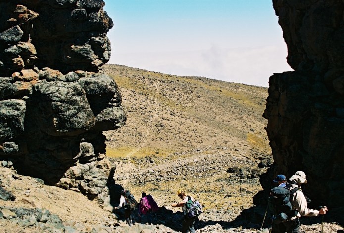
The morning hike was very similar to Day 2, with the terrain gradually turning into an alpine desert. After a couple of hours, we reached the Lava Tower.
Lava Tower

Lava Tower is a 300 ft formation at 4642 meters (15,229 ft) that is reached about lunchtime on Day 3 of the Machame Route.


We had our lunch in the shade of Lava Tower and then three of us decided to climb it.

It only takes 45 or 60 minutes to climb Lava Tower and it was one of the highlights of our time on the mountain.


Leaving Lava Tower, we descended to Barranco Camp as the desert gave way to moorlands with large senecio plants, lobelia, and other beautiful plants.


Kilimanjaro: Machame Route Day 4
Barranco Hut to Karanga Valley

Barranco Hut (3900 m /12,800 ft) to Karanga Valley (3963 m /13,000 ft)
Hiking time: Approximately 4 hours
Distance: Approximately 4 km /2.5 miles
Habitat: Alpine desert
Dining on Kilimanjaro

Our meals on the mountain were prepared by our cook, who did an amazing job – especially considering all our food for a week was hauled in with us on day one.

For breakfast and dinner, a blanket was spread on the ground and we would gather around our “table” and discuss the events of the day, either planned or experienced. Breakfast usually consisted of bread, spreads, hot cereal, fruit (at least the first few days), eggs, coffee, and tea. Lunch was sent with us and was normally a sandwich, hard-boiled egg, and fruit. Dinner always started with soup, then ranged from spaghetti and meat sauce to chicken and rice, with vegetables, breads, coffee, and tea.
We also brought snacks – lots of them. By day four, salty snacks were like gold. We would have sold our car for another canister of Pringles. We also used them as currency – “I’ll pack up your sleeping bag for 5 pringles.”

The Barranco Wall
After breakfast on day four, we immediately began a steep climb up the Barranco Wall.


It honestly looks harder than it is.

Once over the Barranco Wall, we headed down the Karanga Valley to our next camp at Karanga Valley.

Doing the Machame Route in 7 days instead of 6 days, allowed for days 4 and 5 to be short climbing days, which provided for a bit of rest before the summit and better acclimatization. This was a short day, so we had quite a bit of time in camp to rest, relax and take short hikes to view the plants and valley.


Kilimanjaro: Machame Route Day 5
Karanga Valley to Barafu Hut

Karanga Valley (3,963 m /13,000 ft) to Barafu Hut (4,600 m /15,091 ft)
Hiking time: Approximately 3.5 hours
Distance: Approximately 4 km/2.5 miles
Habitat: Alpine desert

Another short climbing day, the trek from the Karanga Valley to Barafu is a day to enjoy the views and appreciate where you are and where you’ve been.

Barafu

Nicknamed, barf food, Barafu is an exposed, desolate camp on a narrow ridge at just over 15,000 ft (4600 m).
We arrived early afternoon and were told to get some rest, and possibly sleep, as we would be leaving for the summit at midnight. Sleep – right.
We wandered around and prepped our summit packs. Dinner was early evening and then everyone retired until about 11:00 PM (23:00). At that time, we put on all of our layers and prepared to hike all night.

Kilimanjaro: Machame Route Day 6 – Summit Day
Barafu Camp to Summit to Mweka Camp

Barafu Camp (4,600 m /15,091 ft) to the Summit (5,896 m/19,340 ft) and then to Mweka Camp (3,100 m/10,170 ft)
Hiking time to summit: Approximately 7 hours
Distance: Approximately 5 km /3.2 miles
Habitat: Stone scree and ice-capped summit
Descent time: Approximately 5 hours
Descent Distance: Approximately 12 km/7.5 miles
The day we were waiting for had come – summit day.
Our “day” began at midnight. The night was clear with a full moon. We were bundled up heavily to prepare for the cold and had lighter summit packs for the anticipated 9 or 10-hour trip.
Our single file of headlamps started our way up through the night. We would stop very briefly every hour or so, but our guides pretty much kept us moving slowly.
I knew I wouldn’t want to eat, so I took numerous packets of chocolate Gu for energy. We didn’t bother with a hydration system since we knew the tube would freeze. We put our water bottles in insulated holders – they still froze by about 1/2 way to the summit.
It was cold – the last time we checked it was minus 10 degrees Celsius (about 14 Fahrenheit) and it got colder, but there was no wind, so we were never really uncomfortable. We didn’t take pictures until we got to the crater…we just kept on trudging up.
At sunrise, we reached the crater. It was fabulous.

After hours of climbing in the dark, the combination of sun and wandering through the glaciers was magical.


It is another 45 minutes or so to the summit from that point. It was an odd combination of wanting to run & make the summit and take our time and take it all in. I guess we opted more for the latter because the guides kept telling us to move along.

We reached the summit at Uhuru Peak at 6:45AM. After pictures, we started back down.

We reached Barafu and got water and a slight rest break then headed to Mweka Camp.


Kilimanjaro: Machame Route Day 7
Mweka Hut to Mweka Gate

Mweka Hut (3,100 m/10,170 ft) to Mweka Gate (1,828 m/6,000 ft)
Hiking time: Approximately 4 hours
Distance: Approximately 10 km/6.21 miles
Habitat: Forest
When we reached Mweka Camp in the afternoon of Day 6, we rested and cleaned up a bit, then started organizing our stuff.
We gathered all of the remaining snacks and I took them over to the guides, who were casually listening to a soccer game – it was just another day for them on the mountain. We left Mweka camp the next morning and it was just a few hours to the Mweka Gate.

We bought beers at the gate and enjoyed the last of our time on Kilimanjaro. We pooled money and tipped our guides. Greg and I also gave them most of our gear. We kept our boots, poles, and packs, but gave them most everything else. We thought they could use it more than we needed it, or they could sell it and use the money. They were a great group of guys.
We then loaded up in the van and headed back to Moshi for a day of rest before we headed on a photo safari for the next week.
Asante sana to everyone that made our climb a success!

Photos: Kim Hull, Greg Hull, Kathy Morse, Tina Santizo
Disclosure & disclaimer: The content & opinions expressed are entirely our own. Reviews are opinion only and Chasing Light Media accepts no responsibility for how the information is used. Some posts on this website may contain links to our partners’ websites and Chasing Light Media may be compensated by those partners.